Tuesday, April 3, 2012

Stem and leaf plot


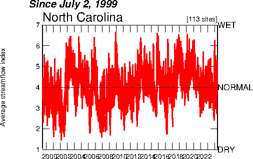
A stem and leaf diagram is a diagram that show raw data in many different ways including but not limited to graphs, tables, and charts. The data in the plot is arranged by place value. Stem and lead plots can be vital to a large fortune five hundred company with thousands of employees that are trying to keep track of their budget and their bottom line. They are great when someone is trying to store a large amount of information in a small place. This graph is a great representation of data that has been arranged to be viewer friendly while using place values to its advantage.

http://mainland.cctt.org/mathsummer/josephbond/stemandplots/stem-and-leaf_std.htm

Box plot


A box plot is an image which uses a graph to depict statistical information. Different section the statistical box plot encompass the graph starting with the sample minimum, lower quartile, median, upper quartile, and sample maximum. In addition, off the wall numbers which far exceed the data sets are numbers that we refer as to outliers. This graph represents all of the data we discussed except the outliers.

http://ellerbruch.nmu.edu/cs255/jnord/boxplot.html

Histogram

A histogram is a common graph which represents graphical data through statistics and allows the viewer of the graph to see clearly how the information has been distributed. The core use of a histogram is for plotting large amounts of data that need to be analyzed and put to use. This could be anything from production of livestock to the bottom line of a sales company that needs to make a certain amount by the end of the year.

http://en.wikipedia.org/wiki/Histogram

Parallel coordinate graph


A parallel coordinate graph is in a league of its own. This graph is so confusing to understand that the whole goal of the graph is not make you learn some new type of date but to show you how data can correlate to each other even if you don't understand the data itself. These types of graphs that involve a lot of lines are generally hard to read but once the beginning point is given, the flow of the chart will come to the viewer a lot easier.

http://vis.lbl.gov/Vignettes/Drosophila/index.html

Triangular plot


A triangular plot uses a graph to represent three different ratios of variable to depict a certain representation of material. These graphs are usually associated with physical science coursed such as chemistry, biology, and oceanography. The proportions and variables must all equal each other. This illustration is a good representation of a triangular plot because it represents three different variables which are percent clay, percent silt, and percent sand and they are made into a triangular graph and depict a certain physical science subject matter.

http://www.westone.wa.gov.au/toolbox6/hort6/html/resources/depot/hort_file/pyramid/text_alt.htm

Windrose


A windrose is a tool that is highly utilized by meteorologists to forecast wind speeds and directional flow. A windrose originated from the term "compass rose" which tells direction. The windrose shows a wide band of wind direction and uses different colors to plot directional flow and speed. This diagram is a perfect example of what I have just described. It compares to a compass rose with the directional flow but uses colors to show the variation in the directional flow and wind speed.

http://www.vistadatavision.com/wind-rose/

Climograph


A climograph is a basic map that shows graphical information that represents climate material such as rainfall, average temperature, heat index, and humidity levels. Most people use a climograph for reviewing weather patterns at the fly versus actually sitting down and analyzing the patterns from a finer point of view. This climograph represent the average temperature for Pensacola, Florida from a year round perspective. The number and months are represented clearly as well as the temperatures.
 
http://www.pensacolainformation.com/weather.html

Monday, April 2, 2012

Population profile


A population profile map is very similar to the U.S. Census. A population profile can be very useful in this day and age because it can show us different population, demographics, racial characteristics, and even house occupancy rates. This image shows us the population profile census for the state of Florida for 2010.

http://www.census.gov/geo/www/maps/2010_census_profile_maps/census_profile_2010_main.html

Scatterplot


A scatterplot is very common and is a mathematical design that displays different variables and raw data that helps us gain a better grasp and understanding of the material that is being presented. Scatterplots can be used in many different situations from sports, sales, and exercise to race car driving, transportation modes, and instructional manuals. This illustration is a perfect example of a scatterplot. It has all of the variable sets that which are being illustrated to help explain to the general public.

http://onlinestatbook.com/chapter4/pearson.html

Index value plot


An index value plot is one that you can view different variations in different situations. A good example of an index value plot would be any map that deals with different figures relating to stream flow or different vibrations related with a seismograph relating to a weather phenomenon such as an earthquake. This graph represents all the different variations of stream flow of different streams in North Carolina since July of 1999.

http://waterwatch.usgs.gov/regplots/real/real_nc_2.gif

Lorenz Curve


The Lorenz Curve is described as one that has a graphical representation to demonstrate what the bottom percentages are of any given study. These bottom percentages could be any raw data set including the bottom household incomes for particular areas of the country. In addition the Lorenz Curve has numerous statistical calculations that help to explain how the "bottom line" or the "bottom percentages" were calculated. This simple graphic represents a Lorenz Curve and exemplifies the bottom percentages and inequalities.
http://ingrimayne.com/econ/AllocatingRationing/MeasuringIncomeDist.html

Sunday, April 1, 2012

Bilateral graph


A bilateral graph is different than what you would think of if you had to come up with a map. When you think of a map, you don’t exactly think of a chart or a graph but that is exactly what this type of map is. A bilateral graph compares two different variables that tend to overlap one another. This map in particular shows exactly where the chart crossed each other and tracked the variables that the US trade deficit with the world had gone through.
  
http://seekingalpha.com/article/241440-will-october-s-improved-trade-deficit-continue

Nominal area choropleth map


A nominal area chlopoleth map is one that is presented with a very simplistic type of style. There are no crazy intimate details, it is all laid out in simple terms to where a ten year old would be able to read that style of map. On these maps there are no types of information explaining deserts, water, bodies, or mountain ranges. They specifically show countries and major cities. This map in particular definitely qualifies because it is a very simplistic map and shows the locations of the different countries in Europe.
http://web.cs.wpi.edu/~matt/courses/cs563/talks/nominal_data/geopolitical.gif

Unstandardized choropleth map


An undstandardized chloropleth map uses raw number from the data instead of using a standardized values, that why its called an "unstandardized map". In addition, the maps used data sets that are used by numerical values gathered from the information that is going to be presented. A lot of times different colors and shading patterns are used to present the different pieces of information. The information present in the above map shows us the growing Hispanic population in the United States. The variables in the map are not averaged and are not standardized.

 http://naturalspecialtyfoodsmemo.blogspot.com/2008/05/ethnic-retailing-memo-wal-mart-to-open.html
 

Standardized choropleth map


Standardized chloropleth maps are a variation of chloroplath map that do a very complete and efficient job of explaining all of the information in an efficient manner. The standard chloropleth map uses a formula that is constantly being updated and always had an accurate way of presenting the different types of material. The different subjects are always being divided into a particular subsection which in turn makes the material accurate and understandable. This map is a perfect example of a standardized chloropleth map because it illustrates and calculates the population and densities per square mile of the people that live in this country.

http://upload.wikimedia.org/wikipedia/commons/thumb/7/78/USA_states_population_density_map.PNG/800px-USA_states_population_density_map.PNG

Univariate choropleth map


A Univariate choropleth map shows us a single variable that is used as data to express information over a broad area of land. A lot of time the variable will be displayed on a map via a color scheme or at least in a form of shading. Many of times these maps are singled out as the "easiest" to read and most easily understood. This particular map show us and estimation of individual that live in poverty. It presents one set of data which is then defined by that particular color scheme.

http://www.cdc.gov/pcd/issues/2007/oct/images/07_0091_02.gif